| |
MAP NEWS |
Upcoming Activities
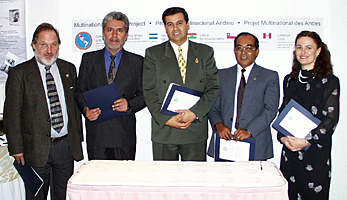
Executive Council MeetingThe recent MAP Executive Council Meeting took place in Toronto, Canada, in conjunction with the Prospectors & Developers Association of Canada (PDAC) convention, from March 14 to 17, 1999. It was attended by:
Meeting Highlights MAP Booth at PDAC Trade Show (March 14-17, 1999): Information about the Multinational Andean Project was displayed in the MAP booth along with maps and posters from the participating countries. The Argentina and Peru booths were also extremely popular with Canadian mineral exploration companies, who showed enthusiastic interest in the Project, and are looking forward to MAP products such as the Metallogenic Map (Geological and Mineral Resources Map) and the future availability of airborne geophysical surveys. Signing of Memorandum of Understanding Between Chile and Canada: On Sunday evening (March 14, 1999), a Memorandum of Understanding (MOU) was signed between national geoscience agencies of Chile and Canada emphasizing cooperation in many areas of geoscience between these countries. Signing for Chile was Ing. Ricardo Troncoso, National Director of SERNAGEOMIN, and for Canada, Dr. Marc Denis Everell, Assistant Deputy Minister of Earth Sciences Sector, Natural Resources Canada. Similar MOU's have previously been signed with Argentina and Peru. Guests at the signing reception included members of the MAP Executive Council, the Director General of the Geological Survey of Canada (Minerals and Regional Geoscience Branch) Murray Duke, and the Director of GSC Pacific, Sandy Colvine; as well as Juan Salazar, an Economic Counsellor representing both the Embassy of Peru and the Consulate of Peru in Canada. Argentina Presentation and Reception (March 15, 1999): Members of SEGEMAR hosted a reception on Monday afternoon, including a presentation about MAP by Project Manager Dr. Catherine Hickson. It was attended by over 100 people, including many Argentineans and other South Americans, as well as Canadians, including Linda Keen, Assistant Deputy Minister of Minerals and Metals Sector, Natural Resources Canada. Highlights from the MAP Executive Council Meeting: One of the first items of business was to choose a new Executive Secretary. Ing. Marcelo Claure of Bolivia sent a letter of resignation to the council stating that other pressing matters occupy his time. Ing. Claure is to be congratulated and thanked for his guidance and leadership during his term as MAP Executive Secretary. Promptly elected from the Directors of one of the national geoscience surveys was Lic. Roberto Page of Argentina. He proceeded to ably chair the rest of the Executive Council meeting. Action ItemsMAP Publications: Countries are sending in lists of publications to be posted on the Web page. It was agreed that all MAP participant countries should have access to all the MAP products, which are to be identified with the MAP logo or text. Countries are to share MAP publications with each other's libraries, including the GSC Vancouver's Cordilleran Geoscience Library, for better availability; and the possibility of selling MAP products through GSC Vancouver was discussed. All countries are to forward 5 copies of all MAP publications to MAP administration for cataloguing and distribution to each country's project leader. The project leader will ensure the publications are forwarded to their library.
Cartographic Standards Committee (CSC): It was agreed that the Geological and Mineral Resources Map of the border regions between Argentina, Bolivia, Chile, and Peru north of 34º (1:1,000,000) would be created using Canadian cartographic standards. It is to be produced by a small working group spending one month in Canada during April, 2000. The first meeting of the CSC is to be held near the end of June in Peru. A list of participants for the International Cartographic Association meeting in Ottawa, August 14-17, 1999 shall be sent to MAP Administration as soon as possible (reduced fees end April 15). The Geological and Mineral Resources Map of the border regions is to be ready to present at the special MAP symposium to be held as part of the Chilean Geological Congress, August 2-4, 2000, and at the IGC Rio meeting to follow (August 6-17, 2000). Mineral Deposits Field Trip (May 2 to 18, 1999): Itineraries for the mineral deposits tour of Bolivia and Argentina were distributed, and about 14 participants were suggested. Ing. Mallo has outlined visits to the following mines and deposits in Bolivia: Kori Kollo, Bolivar, San Bernardino, Potosi, Pulacayo, Uyuni, and San Cristobal; and in Argentina, Dr. Zappettini plans visits to Pirquitas, Aguilar, Fenix, Tincalayu, La Alumbrera, and Agua Rica. As well, a ground-based regional geological overview will be given. Airborne Geophysical Surveys: Following successful completion of Argentina's Austral-Puna Airborne Geophysical Survey, further airborne geophysical work was proposed by all the participating countries. Argentina and Chile are planning to cooperate on a southern continuation of the previous MAP area in a joint airborne geophysical survey covering an area from 31 to 32º50' S latitude and 69º40' to 71ºW longitude, with 1-km line-spacing in a north-south direction, and east-west control lines at 7.5 km, totalling 30,000 line-kilometres. Dr. Dennis Teskey, geophysical consultant for MAP, is investigating private sector interest in taking part in the survey as well as the funding, which will be jointly provided by Argentina, Chile, and private sector companies. In addition, enthusiastic common interest in airborne surveys in other countries resulted in a single cooperative project proposal from Peru, Bolivia, and Chile. An airborne geophysical survey along the western Cordillera in the border areas of Peru and Bolivia from latitude 15º30' S to 21ºS has been proposed. All agreed it was a good idea to include parts of Chile as well (to accommodate irregular borders and foster multicountry cooperation). Private sector interest will be gauged by Dr. Dennis Teskey. Training offered: Information was distributed on a Prospecting Course. A Mineral Deposits Course offered by Dr. Andre Panteleyev is also available. Dr. Panteleyev's previous course, given in Peru, was extremely successful, with over 45 participants. Other types of training were discussed, such as use of the PIMA spectrometer or FieldLog training. MAP Multicountry Fellowship Fund Proposal: As reported in December 1998, Argentina proposed that money be set aside by participating countries of MAP to be used for funding travel expenses and training costs of MAP scientists on exchange programs. It was agreed that the fellowship would be limited to US$5,000 per year per country, and Terms of Reference were signed by all participants. Specifically excluded from the activities financed by the Fellowship fund are assistance toward attending MAP Council meetings, work visits to Canada, participation in regular university courses, and assistance toward attending specialized scientific conferences outside of the continent of South America. To apply for funding through the MAP Multicountry Fellowship Fund, the national project leader is to send a written proposal to the MAP Project manager, endorsed by the national geoscience agency, it will include the name and curriculum vitae of the candidate, justification for the activity in terms of its significance to the Project, and a realistic cost estimate, at least one month before the start of the activity. Final funding decisions are made in cooperation between the Manager and Scientific Advisor of the Project. Once an activity is funded, in total or in part, through the MAP Fellowship Fund, it is necessary to submit a written report to the Project Director, signed by the national leader, detailing the results of the activity. If no report is presented, then future proposals from the same country will not be funded until all requirements are duly met. Everyone agreed that this Fellowship Fund would make it easier to facilitate more equitable scientific exchange among the participating countries. Update on Sample Processing: A report was given by Project Manager Dr. Catherine Hickson and sample coordinator Dr. Jennifer Getsinger. Sample processing data is to be reviewed and updated regularly, and missing information supplied. Formal reports will be produced when appropriate information is complete. It was agreed that until the University of British Columbia (UBC) geochronology laboratory is operational, all samples requiring K-Ar dating will be sent to the Chilean lab. Creation of National Standards for Geochemistry: A summary report by Dr. Getsinger (GSC) and Dr. Kelly Russell (University of British Columbia) on establishing standards for volcanic geochemistry was presented. It was agreed that samples of five rock types would be collected by the four countries in sufficient quantity to allow for geochemical testing and selection as standards, to be further characterized petrologically and eventually to be distributed as geochemical standards for the use of all participant countries. Names of people to contact in relation to geochemistry in each country, and the rocks to be collected are:
MAP Executive Council Dinner: A closing dinner held on Wednesday, March 17, 1999 was attended by MAP Council members and spouses; as well as Ms. Barbara Karpinski and Ing. Jean-Claude Lauzier of CIDA; Ing. René A. Renjel Domínguez, the Vice-Minister of Mining and Metallurgy of Bolivia; and Lic. Roberto Sarudiansky, the Director of the Argentinian Institute of Mining Technology for SEGEMAR (Argentina). The Bolivian Vice-Minister stated how important MAP is to his country, and applauded the progress it has made and the high degree of cooperation it has engendered. Upcoming Executive Council Meetings: At the invitation of the Bolivians, the next MAP Executive Council meeting will be held in La Paz on August 21-23, 1999. The following meeting is planned for Vancouver, in conjunction with the Cordilleran Exploration Roundup, the week of January 25, 2000. |
|||||||||||||||||||