 |
 |
|||||
|
|
 Interagency Volcanic Event Notification Plan IVENP (CANADA) February 2001 INTERIM Environment Canada Emergency Preparedness Canada Geological Survey of Canada Provincial Emergency Program Transport Canada Aviation Nav Canada Yukon Emergency Measures Organization (Except from original document) Forward The Interagency Volcanic Event Notification Plan (IVENP) is the result of the cooperation of the participating agencies to address concerns within their organizations and among members of the public. The plan has been in draft form since 1991 and was raised to interim status in August of 1992. During 1992 testing of the plan was carried out through our response to the eruptions of Mount Spurr in Alaska. On November 27, 1992 the Volcanic Eruption/Ash Hazard Working Group met and agreed that the plan had undergone sufficient testing that it should no longer be considered interim. Henceforth, the plan will undergo updating, testing and revision on a yearly basis under the guidance of the Volcanic Eruption/Ash Hazard Working Group. Information on the plan can be obtained from the Chairman of the Volcanic Eruption/Ash Hazard Working Group, Dr. C.J. Hickson, Geological Survey of Canada, Pacific Division, #101 - 605 Robson Street, Vancouver, British Columbia, V6B 5J3. Corrections, revisions or comments on the plan should be sent to Dr. Hickson by April 1st of each year to be included in the yearly update. Purpose The purpose of Interagency Volcanic Event Notification Plan is to outline the notification procedure and responsibilities of the various agencies that would be involved in response to a geological emergency at a Canadian volcano (Figure 1). The procedures outlined in this document are not intended as a coordination plan between agencies. In the event of volcanic emergency, a facilitation and coordinating committee would be struck to deal with the emergency on an ongoing basis. This committee would ensure a high level of coordination between the agencies mentioned in this document and other involved agencies to minimize loss of life and damage to property before, during, and after a hazardous geological event. Preamble British Columbia and the Yukon encompass a geologically dynamic region. As a consequence of this dynamic environment, some 100 volcanoes and volcanic fields have formed in the geologically recent past (2 million years, Figure 2). These volcanoes are arranged in five broad belts and eruptions within each belt have occurred in the last 10,000 years. The types of volcanoes range from small "basaltic" cinder cones, to peralkaline shield volcanoes, and "dacitic" strato-volcanoes. In terms of eruptive styles, these have ranged from "Hawaiian" type "basaltic" eruptions consisting largely of lava flows and localized tephra (ash) distribution to eruptions on a similar or larger scale to that of May 18th, 1980 "dacitic" eruption at Mount St. Helens. As the tectonic forces that produced these volcanoes and volcanic fields are still active today, it must be assumed that potential for a volcanic eruption in Canada, still exists. Thus, it seems prudent that agencies responsible for emergency measures in the event of a volcanic eruption be made aware of the dangers and a notification plan be implemented and updated on a regular basis. A second factor to be considered is the impact on Canada from eruptions elsewhere in North America. Within 24 hours of the May 18, 1980, eruption of Mount St. Helens, enough tephra fell in southern BC, Alberta and Saskatchewan to cause concern among residents and the aviation community. During the 1989-1990 explosive eruptions of Mount Redoubt, Alaska, tephra drifted into Canada on at least two occasions. Following the three explosive eruptions of Mount Spurr in 1992, ash drifted over Canada, disrupting air traffic and falling to the ground over central Yukon on one occasion. Two prehistoric eruptions of Mount St. Helens left readily observable ash layers in southern BC and the eruption of Mount Mazama (Crater Lake, California) left a blanket of ash several centimetres in thickness over much of southern BC and most of Alberta. It is quite likely that Canada has been dusted by other tephras that have not been preserved in the geological record. When eruptions like these occur again, they will have significant impact on aviation and residents in Canada. 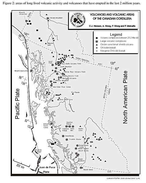 |