|
|
 |
INGEOMIN has progressed in the following activities:
Geologic Hazards Map of the Metropolitan Area of M?rida: INGEOMIN has started the compilation of information, fieldwork and map preparation. A preliminary inventory of natural hazards of 40 localities was carried out. During this stage, the maps of slopes were prepared at a scale of 1:25.000, as well as an inventory of critical areas for the metropolitan region of M?rida.
As part of the process of scientific information diffusion and project promotion, INGEOMIN has conducted meetings with the local municipal administrations and other organizations including the Foundation for Seismic Risk Prevention (FUNDAPRIS) and the Institute for Natural Hazards Management of the Province of M?rida (IMPRADEM). Both organizations have shown interest in supporting and contributing directly to the project.
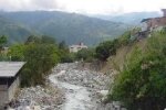
Mucuj?n River Basin: In cooperation with PMA:GCA and the Ministry of Environment and Natural Resources of Venezuela (MARN), INGEOMIN began evaluation of natural hazards in the Mucuj?n River basin. This river is the main water source for the city of M?rida, Venezuela.
Work has been done on the natural hazard-zoning map, identifying vulnerable areas and possible consequences on infrastructure and the population. INGEOMIN began implementation of a GIS and a plan of action for natural hazards prevention and mitigation, as well as hazard maps creation for critical basins.
|
|
|
 |
|